
Land can be put forward for East Suffolk's new Local Plan until 16 November. It must find at least 15,000 more homes; Woodbridge already has seven sites.
East Suffolk Council has reopened its Call for Sites. Landowners, developers, businesses and residents can put land forward for the district’s new Local Plan until 5pm on Monday 16 November.
The plan will decide where homes, jobs and community buildings go up to 2045. It has to find room for at least 15,000 more homes than are already planned for.
The council announced the reopening on 5 October. The first round ran from 20 October 2025 to 9 January 2026 and drew about 500 sites. Seven of them are in Woodbridge parish and nine in Melton.
The numbers behind it
The council’s Call for Sites page sets out the housing target the new plan has to meet:
- 1,658 homes a year is East Suffolk’s figure under the government’s “standard method”, as of September 2026
- 916 homes a year is what the two current Local Plans provide for
- around 80% is the increase between the two
- over 31,000 homes must be provided for across the plan period
- just over 16,000 of those are already covered by permissions and allocations that have not been built
- at least 15,000 more must be found in the new plan
The council says the second round “does not mean more dwellings will be allocated”. It wants a wider choice of land, including sites for employment.
What can be put forward
Sites can be put forward for:
- housing, of at least three homes
- commercial and leisure use
- infrastructure, such as community facilities
- green infrastructure, such as open space or biodiversity net gain land
- other types of development
The release says sites for three or more homes “will now be accepted”. It does not say what the threshold was in the first round.
Anyone who put a site forward last time does not need to do it again. A changed boundary needs a new form, according to the council’s submission guidance.
Submitting a site does not mean it will be allocated, and it does not grant planning permission.
What is already on the map near Woodbridge
The council has published a map of every site from the first round. It shows each site’s outline, a reference number and the proposed use, but no address, owner or parish.
We placed all 503 outlines on that map into parishes, using the council’s own parish boundary layer and the centre of each outline. Of the 503, 455 include housing among their proposed uses.
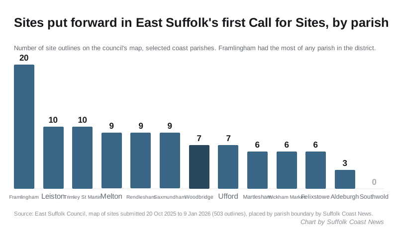
| Parish | Sites | Largest site |
|---|---|---|
| Framlingham | 20 | 50.9 hectares, housing, infrastructure and green space |
| Leiston | 10 | 18.4 hectares, “other” |
| Trimley St Martin | 10 | 115.6 hectares, commercial and infrastructure |
| Melton | 9 | 16.1 hectares, housing, commercial, infrastructure |
| Rendlesham | 9 | 382.3 hectares, commercial and leisure |
| Saxmundham | 9 | 31.2 hectares, housing, infrastructure and green space |
| Woodbridge | 7 | 31.9 hectares, housing and “other” |
| Ufford | 7 | 9.0 hectares, housing, commercial, infrastructure |
| Martlesham | 6 | 17.7 hectares, housing, commercial and “other” |
| Wickham Market | 6 | 30.5 hectares, housing, commercial and green space |
| Felixstowe | 6 | 36.2 hectares, housing |
| Aldeburgh | 3 | 4.4 hectares, housing |
| Southwold | 0 | none |
Framlingham has more sites than any other parish in the district.
Some of the bigger outlines near Woodbridge, with the council’s reference numbers so you can find them on the map:
- Site 165, Woodbridge: 31.9 hectares for housing and other uses, on the western edge of the town around Grundisburgh Road
- Site 244, Woodbridge: 8.6 hectares for commercial and leisure use, by Seckford Way
- Site 442, Melton: 16.1 hectares for housing, commercial, infrastructure and green space, on the north side of the village towards Bredfield
- Sites 145 and 146, Martlesham: 17.7 and 16.7 hectares, both including housing, at Martlesham Heath
- Site 102, Kesgrave: 51.4 hectares for mixed uses, around Grange Farm
- Site 388, Hasketon: 41.3 hectares including housing, by the A12 west of Melton
- Site 164, Rendlesham: 382.3 hectares for commercial and leisure use, near Wantisden Road. It is the second largest site anywhere in the district.
The street descriptions are our reading of where each outline sits. Check the council’s map for the exact boundary.
What happens next
The Local Plan timetable runs like this:
| When | Stage |
|---|---|
| 5 October to 16 November 2026 | Call for Sites reopened |
| May to June 2027 | Consultation on proposed content and evidence |
| February to March 2028 | Consultation on the proposed Local Plan |
| September 2028 to March 2029 | Examination |
| April 2029 | Adoption |
The new plan will replace the Suffolk Coastal and Waveney Local Plans, adopted in 2019 and 2020.
What it means for you
- If you own land, you have until 5pm on 16 November to put it forward on the council’s online form. You can also email planningpolicy@eastsuffolk.gov.uk or post a form to Riverside, 4 Canning Road, Lowestoft NR33 0EQ.
- If you live near a submitted site, nothing is decided yet. The first chance to comment on which sites the council prefers is the consultation planned for May to June 2027.
- If you want to follow it, the council runs a Local Plan mailing list, linked from its Call for Sites engagement page.
The council’s planning policy team is on 01394 444557.
For the applications already in the system, see our East Suffolk planning news.
Have your say